Big Bend National Park
| Big Bend | |
| National Park | |
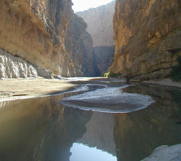 The Rio Grande, separating Mexico and the United States, within the walls of Santa Elena Canyon.
|
|
| Country | |
|---|---|
| State | |
| Region | Chihuahuan Desert |
| City | Alpine (nearest) |
| River | Rio Grande |
| Location | Brewster County, Texas |
| - coordinates | |
| Highest point | |
| - location | Emory Peak, Chisos Mountains |
| - elevation | 2,387 m (7,831 ft) |
| Lowest point | |
| - location | Rio Grande |
| - elevation | 550 m (1,804 ft) |
| Area | 3,242 km² (1,252 sq mi) |
| Founded | June 12, 1944 |
| Management | National Park Service |
| Visitation | 364,856 (2007) |
|
|
|
| Website: National Park Service | |
Big Bend National Park is a national park located in the U.S. state of Texas. For more than 1,000 miles (1600 km), the Rio Grande/Río Bravo forms the international boundary between Mexico and the United States, and Big Bend National Park administers approximately 244 miles (393 km) along that boundary.
Big Bend National Park has national significance as the largest protected area of Chihuahuan Desert topography and ecology in the United States, which includes more than 1,200 species of plants, more than 450 species of birds, 56 species of reptiles, and 75 species of mammals.[1] The park covers 801,163 acres (3,242 km2).[1] Few areas exceed the park's value for the protection and study of geologic and paleontologic resources. Cretaceous and Tertiary fossil organisms exist in variety and abundance. Archeologists have discovered artifacts estimated to be 9,000 years old, and historic buildings and landscapes offer graphic illustration of life along the international border in the 1800s.
Because the Rio Grande serves as an international boundary, the park faces unusual constraints when administering and enforcing park rules, regulations, and policies. In accordance with the Treaty of Guadalupe Hidalgo, the park has jurisdiction only to the center of the deepest river channel as the river flowed in 1848. The rest of the land south of that channel, and the river, lies within Mexican territory.
Contents |
Geography and climate
The park exhibits dramatic contrasts; its climate may be characterized as one of extremes. Dry and hot late spring and summer days often exceed 100 °F (38 °C) in the lower elevations. Winters are normally mild throughout the park, but sub-freezing temperatures occasionally occur. Because of the range in altitude from approximately 1,800 feet (550 m) along the river to Emory Peak in the Chisos Mountains at 7,832 feet (2,387 m)[1] a wide variation in available moisture and in temperature exists throughout the park. These variations contribute to an exceptional diversity in plant and animal habitats. Some species in the park, such as the Chisos Oak, are found nowhere else in the United States.
The 118 miles (190 km) of river that form the southern park boundary include the spectacular canyons of Santa Elena, Mariscal, and Boquillas. The Rio Grande, meandering through this portion of the Chihuahuan Desert, has cut deep canyons with nearly vertical walls through three uplifts comprised primarily of limestone. Throughout the open desert areas, the highly productive Rio Grande riparian zone includes numerous plant and animal species and significant cultural resources. The vegetative belt extends into the desert along creeks and arroyos.
South of the border lie the Mexican states of Chihuahua and Coahuila and the new protected areas for flora and fauna, which are regions known as the Maderas del Carmen and the Cañón de Santa Elena.
Geology
The oldest recorded tectonic activity in the park is related to the Paleozoic Marathon orogeny, although it is possible that Proterozoic events (over 550 Mya) have some deep control. The Marathon orogeny (part of the Ouachita-Marathon-Sonora orogenic belt) is part of thrusting of rocks from the South American Plate over the North American Plate. This can be best seen in the Persimmon Gap area of the park. This orogenic event is linked to the lack of Triassic- and Jurassic-age rocks in the park.[1]
Between the Triassic and the Cretaceous the South American Plate rifted from the North American Plate, resulting in the deposition of the Glen Rose Limestone, Del Carmen Limestone, Sue Peaks Formation, Santa Elena Limestone, Del Rio Clay, Buda Limestone and Boquillas formations (preserved in the Sierra del Carmen–Santiago Mountains, Nine Point Mesa, Mariscal Mountain and Mesa de Anguila areas). Also during this time, the Chihuahua trough formed as the Gulf of Mexico opened, which resulted in east-west striking normal faulting.[1] As a result of this depositional time, there are dinosaur,[2] forest[3][4] and other fossils preserved in the park.
Following the ending of rifting in the Late Cretaceous to the early Tertiary, the Big Bend area was subjected to the Laramide orogeny. This period of (now east-west) compression caused the northeast-facing Mesa de Anguila (an uplifted monocline on the southwest margin of the park), the southwest-facing Sierra del Carmen–Santiago Mountains (an uplifted and thrust-faulted monocline that forms the boundary of the park on the east) and the Tornillo Basin. During the middle Tertiary most of the volcanic rocks, including the Chisos group, the Pine Canyon caldera complex and the Burro Mesa Formation, formed.[1]
The most recent tectonic activity in the park is Basin and Range faulting from the late Tertiary to Quaternary. This period of east-west extension has resulted in Estufa and Dehalo bolsons in the Chisos Mountains, as well as the Terlingua and Sierra del Carmen, Chalk Draw and Burro Mesa faults. The Rio Grande has entered the Big Bend area roughly 2 Mya, and since then extensive erosion and down cutting has occurred.[1]
Cultural resources
Cultural resources in the park range from the Paleo-Indian period 10,500 years ago through the historic period represented by Native American groups, such as the Chisos, Mescaleros, and Comanche. More recently, Spanish, Mexican, Anglo and Irish settlers farmed, ranched, and mined in the area.
Throughout the prehistoric period, humans found shelter and maintained open campsites throughout the park. The archeological record reveals an Archaic-period desert culture, whose inhabitants developed a nomadic hunting and gathering lifestyle that remained virtually unchanged for several thousand years.
The historic cultural landscape centers upon various subsistence or commercial land uses. The riparian and tributary environments were used for subsistence and irrigation farming. Transportation networks, irrigation structures, simple domestic residences and outbuildings, and planed and terraced farm land lining the stream banks characterize these landscapes.
Human history
During the early historic period (pre-1535) several Indian groups were recorded as inhabiting the Big Bend. The Chisos Indians were a loosely organized group of nomadic hunters and gatherers who probably practiced limited agriculture on a seasonal basis. The origin of the Chisos Indians is not known. Linguistically, they were associated with the Conchos Indians of northern Chihuahua and northwestern Coahuila. Their language group spoke a variation of Uto-Aztecan, a language whose speakers ranged from central Mexico to the Great Basin of the U.S.
The Jumano was a nomadic group that travelled and traded throughout west Texas and southeastern New Mexico, but some historic records indicate that they were enemies of the Chisos. Around the beginning of the 18th century, the Mescalero Apaches began to invade the Big Bend region and displaced the Chisos Indians. One of the last Native American groups to use the Big Bend was the Comanches, who passed through the park along the Great Comanche Trail on their way to and from periodic raids into the Mexican interior. These raids continued until the mid 19th century. The last of the great military leaders of the native peoples of the region was an Apache of Spanish ancestry named Alzate, who was active as late as the late 1860s.
The European presence in the region begins circa 1535 A.D. with the first Spanish explorations into this portion of North America. The expedition of Álvar Núñez Cabeza de Vaca passed near the Big Bend and was followed by other expeditions. Some of these expeditions were searching for gold and silver, and farm and ranch land. Others, such as those by the Franciscan missionaries, were intended to establish centers in which the natives could be evangelized. In an attempt to protect the northern frontier of the New Spain, from which emerged present day Mexico, a line of presidios, or forts, was established along the Rio Grande in the late 1700s. The Presidio de San Vicente was built near present-day San Vicente, Coahuila, and the Presidio de San Carlos was built near present-day Manuel Benavides, Chihuahua. Some of these presidios were soon abandoned, because of financial difficulties and because they could not effectively stop Indian intrusions into Mexico. The soldiers and settlers of these presidios moved to other, newer, presidios in the vicinity of the region, from where the interests of the Spanish Empire were more defensible. Such was the case of Santa Rosa Maria del Sacramento, now Muzquiz, Coahuila.
Very little study has been made of the Spanish occupation of the Big Bend following the abandonment of the Presidios. In 1805, the Spanish settlement called Altares existed 30 miles (48 km) south of the Rio Grande. The region became a part of Mexico when this republic consummated its independence from Spain in 1821. Mexican families lived in the area when Anglo settlers began moving in following the secession of Texas during the latter half of the 19th century.
Following the Mexican-American War, which ended in 1848, military surveys were made of the uncharted land of the Big Bend. Military forts and outposts were established across Trans Pecos Texas to protect migrating settlers from the Indians. A significant proportion of these soldiers were of African American ancestry and came to be known as the "buffalo soldiers," a name apparently given to them by the Native Americans of the region. Lieutenant Henry Flipper, the first American of African ancestry to graduate from West Point, served in Shafter, Texas toward the late 19th century. Shafter is just west of the Big Bend along the highway that goes from Presidio to Marfa. Around 1880, ranchers began to migrate into the Big Bend, and by 1900, sheep, goat, and cattle ranches occupied a majority of the landscape. The delicate desert environment, however, was soon overgrazed.
In the late 19th and early 20th century, the discovery of valuable mineral deposits brought more settlers who worked in the mines or supported the mines by farming or by cutting timber for use in the mines and smelters. Communities sprang up around the mines; development of Boquillas and Terlingua directly resulted from mining operations. During this period, the Rio Grande flood plain was settled by farmers. Settlements developed with names like Terlingua Abajo, San Vicente, La Coyota and Castolon. These were often no more than clusters of families living and farming in the same area, and they were successful only to the degree that the land was able to support them.
In the 1930s, many people who loved the Big Bend country saw that it was a land of unique contrast and beauty that was worth preserving for future generations. In 1933, the Texas Legislature passed legislation to establish Texas Canyons State Park. Later that year, the park was redesignated Big Bend State Park. In 1935, the United States Congress passed legislation that would enable the acquisition of the land for a national park. The State of Texas deeded the land that it had acquired to the Federal government of the United States, and on June 12, 1944, Big Bend National Park became a reality. The park opened to visitors on July 1, 1944.
Flora and fauna
Despite its harsh environment, Big Bend has an amazing variety and number of plant and animal species. It has more than 1200 species of plants (including 60 different cacti species), more than 600 animal species, and about 3600 insect species. The diversity of life is largely due to the diverse ecology and changes in elevation, ranging from the dry, hot desert to the cool mountains to the fertile river valley.
Most of the animals are not visible in the day, particularly in the desert. The park comes alive at night, with many of the animals foraging for food. About 150 mountain lion sightings are reported per year, despite the fact that there are only a total of two dozen mountain lions.[5] Other species that inhabit the park include jackrabbit, kangaroo rat, roadrunner, Golden Eagle, javelina, and coyote. Black bears are also present in the mountain areas.
The variety of cactus and other plant life add color to the Big Bend region. Cactus species in the park include prickly pear, claret cup and pitaya. In the spring, the wildflowers are in full bloom and the yucca flowers display bright colors. Bluebonnets are prevalent in Big Bend, and white and pink bluebonnets are sometimes visible by the road. Other flowering plants such as the desert marigold, desert willow, ocotillo, rock nettle and lechuguilla abound in Big Bend.
The first U.S. record of the Tufted Flycatcher, a Central American species, was from this site in November 1991. Birders also flock to the park as it is home to the only area in the United States within the breeding range of the Colima Warbler.
Tourist information
Big Bend is one of the largest, most remote, and least-visited national parks in the lower 48 United States.[6] In recent years only 300,000-350,000 visitors have entered the park annually.
Big Bend's primary attraction is its hiking and backpacking trails. Particularly notable among these are the Chimneys Trail, which visits a rock formation in the desert, the Marufo Vega trail, a loop trail that passes through scenic canyons on the way to and from the Rio Grande, and the Outer Mountain Loop trail in the Chisos, which begins in the Chisos Basin, climbs into the high mountains, descends into the desert along the Dodson Trail, and then returns to the Chisos Basin, completing a thirty mile loop. Other notable locations include Santa Elena Canyon, Grapevine Hills, and the Mule Ears, two imposing rock towers in the middle of the desert.
The park administers 245 miles (394 km) of the Rio Grande for recreational use. There are professional river outfitters that provide tours of the river. Use of a personal boat is permitted but a free river float permit is required. Until 2002 visitors often crossed the Rio Grande to visit the Mexican village of Boquillas, but the Department of Homeland Security closed the border crossing. In June 2009 the Department of Homeland Security began treating all float trips as trips that had left and re-entered the country, and required participants to have an acceptable form of identification, such as a passport.[7]
Another popular activity is birdwatching with more than 450 species of birds recorded in the park. Many species stop in the park during their migrations.
There are five paved roads in Big Bend. Persimmon Gap to Panther Junction is a 28-mile (45 km) road from the north entrance of the park to park headquarters at Panther Junction. Panther Junction to Rio Grande Village is a 21-mile (34 km) road that descends 2,000 feet (610 m) from the park headquarters at Panther Junction to the Rio Grande River. Maverick Entrance Station to Panther Junction is a 23-mile (37 km) route from the western entrance of the park to the park headquarters. Chisos Basin Road is 6 miles (10 km) long and climbs to 5,679 feet (1,731 m) above sea level at Panther Pass before descending into the Chisos Basin. The 30 mi (48 km) Ross Maxwell Scenic Drive leads to the Castolon Historic District and Santa Elena Canyon.
Big Bend gallery
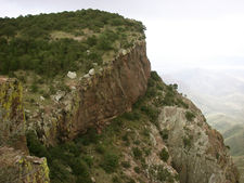
 View from the summit of Emory Peak, loftiest point in Big Bend National Park and monarch of the High Chisos Mountains. |
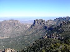
 The South Rim. |
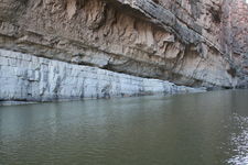 Rock layers in the walls of Santa Elena Canyon. |
 Hikers on the Window Trail in Big Bend National Park |
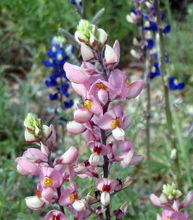 Pink bluebonnets mingling with blue ones |
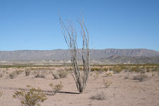 Ocotillo with a portion of the Sierra del Carmen mountain range in the background |
See also
|
|
References
- ↑ 1.0 1.1 1.2 1.3 1.4 1.5 1.6 Gray, J.E.; Page, W.R., eds (October 2008). Geological, geochemical, and geophysical studies by the U.S. Geological Survey in Big Bend National Park, Texas. Circular 1327. U.S. Geological Survey. ISBN 978-141132280-6. http://pubs.usgs.gov/circ/1327/.
- ↑ Lehman, Thomas M.; Coulson, Alan B. (January 2002). "A juvenile specimen of the sauropod dinosaur Alamosaurus sanjuanensis from the Upper Cretaceous of Big Bend National Park, Texas". Journal of Paleontology 76 (1): 156–172. doi:10.1666/0022-3360(2002)076<0156:AJSOTS>2.0.CO;2.
- ↑ Lehman, Thomas M.; Wheeler, Elisabeth A. (February 2001). "A Fossil Dicotyledonous Woodland/Forest From The Upper Cretaceous of Big Bend National Park, Texas". PALAIOS 16 (1): 102–108. doi:10.1669/0883-1351(2001)016<0102:AFDWFF>2.0.CO;2.
- ↑ Wheeler, Elisabeth A.; Lehman, Thomas M. (14 October 2005). "Upper Cretaceous-Paleocene conifer woods from Big Bend National Park, Texas". Palaeogeography, Palaeoclimatology, Palaeoecology 226 (3-4): 233–258. doi:10.1016/j.palaeo.2005.05.014.
- ↑ Uhler, John William. "Big Bend National Park Hiking Guide". Hillclimb Media. http://www.big.bend.national-park.com/hike.htm. Retrieved 2008-07-22.
- ↑ "Encarta". Archived from the original on 2009-10-31. http://www.webcitation.org/5kwQ6NxqA.
- ↑ Big Bend National Park Western Hemisphere Travel Initiative
Bibliography
- Gómez, Arthur R. (1990) A Most Singular Country: A History of Occupation in the Big Bend. Charles Redd Center for Western Studies; Brigham Young University.
- Jameson, John R. (1996) The Story of Big Bend National Park. University of Texas Press.
- Maxwell, Ross A. (1968) The Big Bend of the Rio Grande: A Guide to the Rocks, Landscape, Geologic History, and Settlers of the Area of Big Bend National Park. Bureau of Economic Geology; University of Texas.
External links
- Big Bend National Park website
- Big Bend National Park map (568 KB PDF file)
- Extensive travel information at American Southwest
- 10 Less-Traveled National Parks (Archived 2009-10-31)
- South and West Texas, a National Park Service Discover Our Shared Heritage Travel Itinerary
- Hike Journal of a trip into the Chisos Mountains includes pictures
- Castolon: A Meeting Place of Two Cultures,a National Park Service Teaching with Historic Places (TwHP) lesson plan
|
|||||||||||
|
||||||||||||||||||||||||||||||||||||||||||||||||